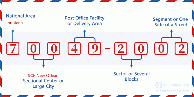
200 HIGHWAY 18, EDGARD, LA 70049-2002
201 HIGHWAY 18, EDGARD, LA 70049-2002
202 HIGHWAY 18, EDGARD, LA 70049-2002
203 HIGHWAY 18, EDGARD, LA 70049-2002
204 HIGHWAY 18, EDGARD, LA 70049-2002
205 HIGHWAY 18, EDGARD, LA 70049-2002
206 HIGHWAY 18, EDGARD, LA 70049-2002
207 HIGHWAY 18, EDGARD, LA 70049-2002
208 HIGHWAY 18, EDGARD, LA 70049-2002
209 HIGHWAY 18, EDGARD, LA 70049-2002
210 HIGHWAY 18, EDGARD, LA 70049-2002
211 HIGHWAY 18, EDGARD, LA 70049-2002
212 HIGHWAY 18, EDGARD, LA 70049-2002
213 HIGHWAY 18, EDGARD, LA 70049-2002
214 HIGHWAY 18, EDGARD, LA 70049-2002
215 HIGHWAY 18, EDGARD, LA 70049-2002
216 HIGHWAY 18, EDGARD, LA 70049-2002
217 HIGHWAY 18, EDGARD, LA 70049-2002
218 HIGHWAY 18, EDGARD, LA 70049-2002
219 HIGHWAY 18, EDGARD, LA 70049-2002
220 HIGHWAY 18, EDGARD, LA 70049-2002
221 HIGHWAY 18, EDGARD, LA 70049-2002
222 HIGHWAY 18, EDGARD, LA 70049-2002
223 HIGHWAY 18, EDGARD, LA 70049-2002
224 HIGHWAY 18, EDGARD, LA 70049-2002
225 HIGHWAY 18, EDGARD, LA 70049-2002
226 HIGHWAY 18, EDGARD, LA 70049-2002
227 HIGHWAY 18, EDGARD, LA 70049-2002
228 HIGHWAY 18, EDGARD, LA 70049-2002
229 HIGHWAY 18, EDGARD, LA 70049-2002
230 HIGHWAY 18, EDGARD, LA 70049-2002
231 HIGHWAY 18, EDGARD, LA 70049-2002
232 HIGHWAY 18, EDGARD, LA 70049-2002
233 HIGHWAY 18, EDGARD, LA 70049-2002
234 HIGHWAY 18, EDGARD, LA 70049-2002
235 HIGHWAY 18, EDGARD, LA 70049-2002
236 HIGHWAY 18, EDGARD, LA 70049-2002
237 HIGHWAY 18, EDGARD, LA 70049-2002
238 HIGHWAY 18, EDGARD, LA 70049-2002
239 HIGHWAY 18, EDGARD, LA 70049-2002
240 HIGHWAY 18, EDGARD, LA 70049-2002
241 HIGHWAY 18, EDGARD, LA 70049-2002
242 HIGHWAY 18, EDGARD, LA 70049-2002
243 HIGHWAY 18, EDGARD, LA 70049-2002
244 HIGHWAY 18, EDGARD, LA 70049-2002
245 HIGHWAY 18, EDGARD, LA 70049-2002
246 HIGHWAY 18, EDGARD, LA 70049-2002
247 HIGHWAY 18, EDGARD, LA 70049-2002
248 HIGHWAY 18, EDGARD, LA 70049-2002
249 HIGHWAY 18, EDGARD, LA 70049-2002
250 HIGHWAY 18, EDGARD, LA 70049-2002
251 HIGHWAY 18, EDGARD, LA 70049-2002
252 HIGHWAY 18, EDGARD, LA 70049-2002
253 HIGHWAY 18, EDGARD, LA 70049-2002
254 HIGHWAY 18, EDGARD, LA 70049-2002
255 HIGHWAY 18, EDGARD, LA 70049-2002
256 HIGHWAY 18, EDGARD, LA 70049-2002
257 HIGHWAY 18, EDGARD, LA 70049-2002
258 HIGHWAY 18, EDGARD, LA 70049-2002
259 HIGHWAY 18, EDGARD, LA 70049-2002
260 HIGHWAY 18, EDGARD, LA 70049-2002
261 HIGHWAY 18, EDGARD, LA 70049-2002
262 HIGHWAY 18, EDGARD, LA 70049-2002
263 HIGHWAY 18, EDGARD, LA 70049-2002
264 HIGHWAY 18, EDGARD, LA 70049-2002
265 HIGHWAY 18, EDGARD, LA 70049-2002
266 HIGHWAY 18, EDGARD, LA 70049-2002
267 HIGHWAY 18, EDGARD, LA 70049-2002
268 HIGHWAY 18, EDGARD, LA 70049-2002
269 HIGHWAY 18, EDGARD, LA 70049-2002
270 HIGHWAY 18, EDGARD, LA 70049-2002
271 HIGHWAY 18, EDGARD, LA 70049-2002
272 HIGHWAY 18, EDGARD, LA 70049-2002
273 HIGHWAY 18, EDGARD, LA 70049-2002
274 HIGHWAY 18, EDGARD, LA 70049-2002
275 HIGHWAY 18, EDGARD, LA 70049-2002
276 HIGHWAY 18, EDGARD, LA 70049-2002
277 HIGHWAY 18, EDGARD, LA 70049-2002
278 HIGHWAY 18, EDGARD, LA 70049-2002
279 HIGHWAY 18, EDGARD, LA 70049-2002
280 HIGHWAY 18, EDGARD, LA 70049-2002
281 HIGHWAY 18, EDGARD, LA 70049-2002
282 HIGHWAY 18, EDGARD, LA 70049-2002
283 HIGHWAY 18, EDGARD, LA 70049-2002
284 HIGHWAY 18, EDGARD, LA 70049-2002
285 HIGHWAY 18, EDGARD, LA 70049-2002
286 HIGHWAY 18, EDGARD, LA 70049-2002
287 HIGHWAY 18, EDGARD, LA 70049-2002
288 HIGHWAY 18, EDGARD, LA 70049-2002
289 HIGHWAY 18, EDGARD, LA 70049-2002
290 HIGHWAY 18, EDGARD, LA 70049-2002
291 HIGHWAY 18, EDGARD, LA 70049-2002
292 HIGHWAY 18, EDGARD, LA 70049-2002
293 HIGHWAY 18, EDGARD, LA 70049-2002
294 HIGHWAY 18, EDGARD, LA 70049-2002
295 HIGHWAY 18, EDGARD, LA 70049-2002
296 HIGHWAY 18, EDGARD, LA 70049-2002
297 HIGHWAY 18, EDGARD, LA 70049-2002
298 HIGHWAY 18, EDGARD, LA 70049-2002
299 HIGHWAY 18, EDGARD, LA 70049-2002


แสดงความเห็น